Information on access from Pungapunga River to the Whakapapa River which is between Taumarunui and the National Park.
To view the access map and brochure click on Lower Whanganui Headwaters.
Please select link below to go directly to the information:
Whakapapa River
Whanganui River
Pungapunga River
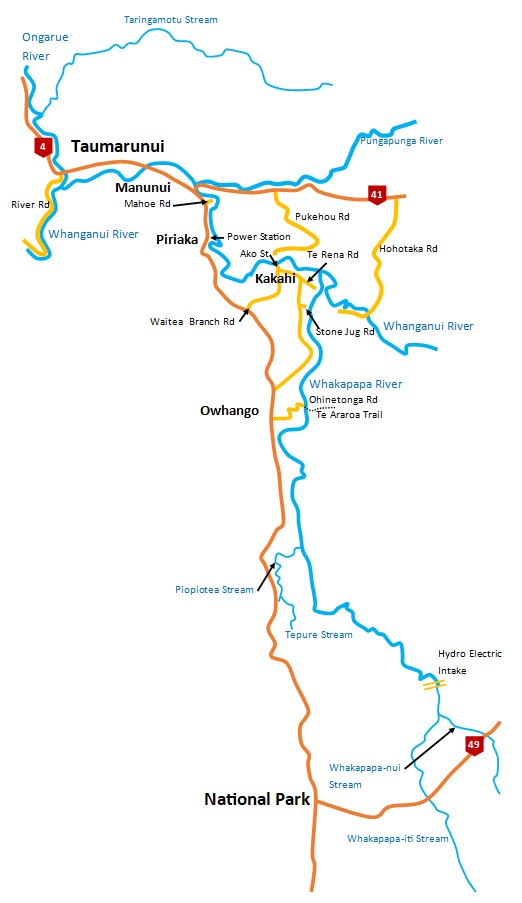
Map of lower Whanganui Headwaters
Whakapapa River
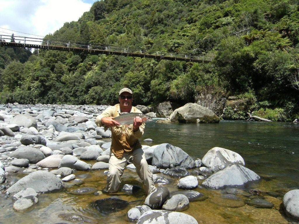
The Whakapapa is a large river that flows from the northern slopes of Mt Ruapehu, along the edge of the Tongariro Forest, before joining the Whanganui River at Kakahi. It is one of New Zealand’s finest trout fisheries with rainbow and brown trout averaging 2kg. Generally, the water quality is pristine, very cold and crystal clear - in the upper reaches water clarity can exceeds 10 metres.
For most of its length the Whakapapa flows through native forest alternating between turbulent rapids, deep pools and long boulder runs. This is certainly not a river for the faint hearted - there are few easy places to cross and some caution is required.
Access to the lower reaches is from the end of Te Rena Road via the village of Kakahi. This is the most popular fishing area on the Whakapapa, providing the easiest fishing as well as giving good access to the nearby Whanganui River by crossing the island. Upstream from Kakahi there is good access at the end of Stone Jug Road. Park at the end of Stone Jug Road and walk down the hill for good access up and downstream.
Access to the middle reaches is from Ohinetonga Road in Owhango where a good metal road leads to bridge across the river. Midway down the hill from Owhango village a track leads to good fishing downstream to several large pools before a narrow gorge prevents further access. The track leading downstream from the bridge is no longer safe to use. Upstream from the bridge a short road on the right leads to several paths providing access to many kilometres of spectacular wilderness fishing with a procession of productive pools and boulder runs.
South of Owhango, access is available at several locations across private farmland from State Highway 4 (Taumarunui - National Park). Permission is not always given. Some maps show a road leading from Mansons Siding to the river, but this is a farm road and closed to public access.
Access to the upper reaches of the Whakapapa via Intake Road has been temporally closed by the new landowner despite a public easement across the property and staff are actively working to reopen the legal public access.
Access to the upper river and tributaries are from HW 47. The Whakapapa-iti and Whakapapa-nui Streams converge to form the Whakapapa River. Both streams hold only a few fish, generally large rainbows (3kg+) in very clear water, with the best fishing in the lower reaches. Fishing this area requires frequent, difficult river crossings and is not recommended for the inexperienced.
Fishing tips
The Whakapapa is deep so most anglers use a Tongariro setup with a float and bedhead nymphs often with additional split shots. Make sure you get your gear deep as the holes are often 3+ m. Czech (or European) Nymphing is also very effective in swift bolder patches.
Whanganui River
Within the Auckland/Waikato Region, the Whanganui River offers a wide variety of fishing waters. Below Taumarunui the Whanganui River receives the full flow of the Ongarue River and along with the considerable increase in flow acquires a brownish tinge. This section offers a unique experience for North Island anglers of a very large river that still has an interesting sequence of pools and runs. Access is easy as the river runs adjacent to River Road.
Between Taumarunui and Kakahi there are numerous good fishing pools please see the map on the Fish & Game web page for further details. This section of the Whanganui consists of long boulder runs and large deep pools with numerous trout, both rainbows and browns, averaging about 1.2kg. Access can be gained from Taumarunui, Mahoe (Mahoe Rd), Piriaka (from the power station), Manunui, Kakahi (Ako Street), and Pukehou Road. Access to the Kakahi side of the river can be gained form walking north on the paper road along the railway off of Waitea Branch Road.
Above the confluence with the Whakapapa, the Whanganui changes to a relatively sedate river flowing over pebbles and sand through a pleasant rural landscape. Access can be obtained from the end of Te Rena Road (Kakahi) by crossing the Whakapapa River and taking the short path across Whakapapa Island. Otherwise access can be gained by walking downstream from Hohotaka Road (permission required from landowner).
Above Hohotaka Road, the Whanganui provides typical backcountry fishing with deep pools, long boulder runs and clear water. Permission is required from the landowner at the farmhouse by the bridge (Whangaipeki X Trust). Hohotaka Road is a metalled road about 8 km east of Manunui on State Highway 41 (Taumarunui - Turangi). Transport and accommodation is also offered by Go Bush Adventures (www.gobush.co.nz).
Access to the headwaters within the Tongariro National Park is via Te Araroa Trail from Owhango or State Highway 47 (Sir Edmond Hillary Outdoor Pursuits Centre). A 4-wheel drive vehicle, motor bike or mountain bike is required, but access does require a map or GPS. This section is rugged backcountry fishing requiring an above average level of fitness and the occasional deep crossing. Good numbers of fish averaging about 2kg can be expected. There is little fishable water above the confluence of the Whanganui with the Mangatepopo Stream because of water abstraction by the Tongariro Power Scheme. This section of the river is suitable for pack rafting for more information visit www.packraftingtrips.nz.
Pungapunga River
A small and easily wadable stream that offers good fly fishing with a high trout population including the occasional large trout that has moved upstream from the Whanganui River. The Pungapunga is best fished in the lower reaches where the stream flows across farmland with the occasional patch of scrub and willow. The river has very little public access so access must be obtained by asking permission from landowners.
Please select image for larger view.