To view the access map and brochure click on Ngaruroro River
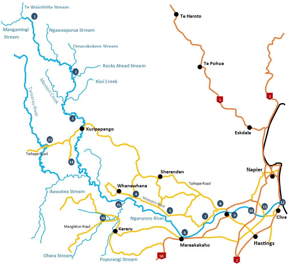
1 - Boyd's Airstrip
A regularly used designated Department of Conservation landing site for fixed wing aircraft and helicopters located in the Kaimanawa Forest Park on an old river terrace above the river. Access within this park, and the Kaweka Forest Park across the river, provides foot access along the river. It is possible to fly into the Boyd and raft down the river to Kuripapango, but care is needed.
2 - Other Landing Sites (Boyd to Kuripapango)
A number of other designated landing sites for helicopters exist between Boyd's and Kuripapango both within the Kaweka Forest Park and privately owned land managed by commercial operators. These include the Department of Conservation Ngaawapurua, Omarukokere, Rocks Ahead, Kiwi Mouth, and Cameron huts. The privately owned areas together with their landing sites are confined to the true right hand side. Permission from the commercial operators is required to land or fish from these sites.
3 - Kuripapango
Access off the Napier-Taihape Road at several points at Kuripapango. Just before the road bridge a picnic site gives access to the river, both upstream towards the Cameron hut with a number of river crossings, and downstream for approximately 1km. The driveway to the Department of Conservation's Robson lodge, alongside the Napier end of the bridge, provides good access to nearly 2km of river downstream of this point. Another picnic area provides access to some pools on the other side of the bridge but slightly upstream. Access for rafts is also available at these points for the keen angler willing to raft out to below Whanawhana.
4 - Whanawhana Road
A 500m gravel road leads off Whanawhana Road and ends up alongside the Ngaruroro River. In this area the river has exited from the upper gorge section and is now an open braided river. Foot access in both directions and across the river is only limited by river flow and depth. Access to Whanawhana Road is via Matapiro Road which is off the Napier-Taihape Road.5.
5 - Mataplro Road
One kilometer past the junction of Omapare Road a private gravel track leads down to the river. Vehicle access is available with landowner permission. Please ring the adjacent landowner (Tony Connor 06-87 4-3886 or son 06-87 4-3841) before using this access point.
6 - Maraekakaho
Two hundred metres along Kereru Road from Maraekakaho Road a metal access road leads off to the right to the river. Provides walking access both upstream and downstream of this point.
7 - Ohiti Road
Approximately 4.5kms along Ohiti Road a gravel vehicle track leads to the river.
8 - Farnhill Bridge (Omahu)
A Regional Council access track on the Napier and upstream side of the bridge passes back under the bridge and heads downstream.
9 - Carrick Road
Another Regional Council access track provides good access both upstream and downstream to the section of river between SH50 and the expressway. Carrick Road is reached off Omahu Road via Twyford, Evans and Nicholl Roads.
10 - Ormond Road
Access to the river is gained off Omahu Road and via Ormond Road.
11 - Chesterhope Bridge (Pakowhai Road)
Regional Council access tracks at both ends of the bridge provides access to the section of the lower river.
12 - River Mouth (Waitangi/Awatoto)
The Regional Council access at this point provides good access to the joint mouths of the Ngaruroro and Tutaekuri Rivers.
Tributary Access
Taruarau River
13 - Napier-Talhape Road (Gentle Annie)
Most of the land in this area is privately owned and landowner permission is therefore required.
14 - Comet Road
Drive to the end of Comet Road, within Kaweka Forest Park, and a Department of Conservation walking track heads steeply down to the Taruarau River 1 1/2 hours away. The return trip will take longer. For those keen to stay overnight there is the option of tenting or Shute's hut, a 20 minute walk from the river.
Ohara/Poporangi Streams
15 - Big Hill Road
Access off Kereru and Big Hill Road. The land at this point is privately owned and landowner permission will be required.
16 - Mangleton Road
Public access for 3km up the Ohara Stream exists from the road bridge.
Select map for larger view